Unakoti: Where Ancient Shaivite Legends, Stone Carvings, and the Living History of Tripura Converge
Unakoti is one of those places where geography, myth, and history refuse to stay in separate boxes. It sits quietly in northern Tripura, surrounded by forested hills and seasonal waterfalls, yet carries layers of time that stretch from ancient Shaivite worship to modern administrative reshaping.
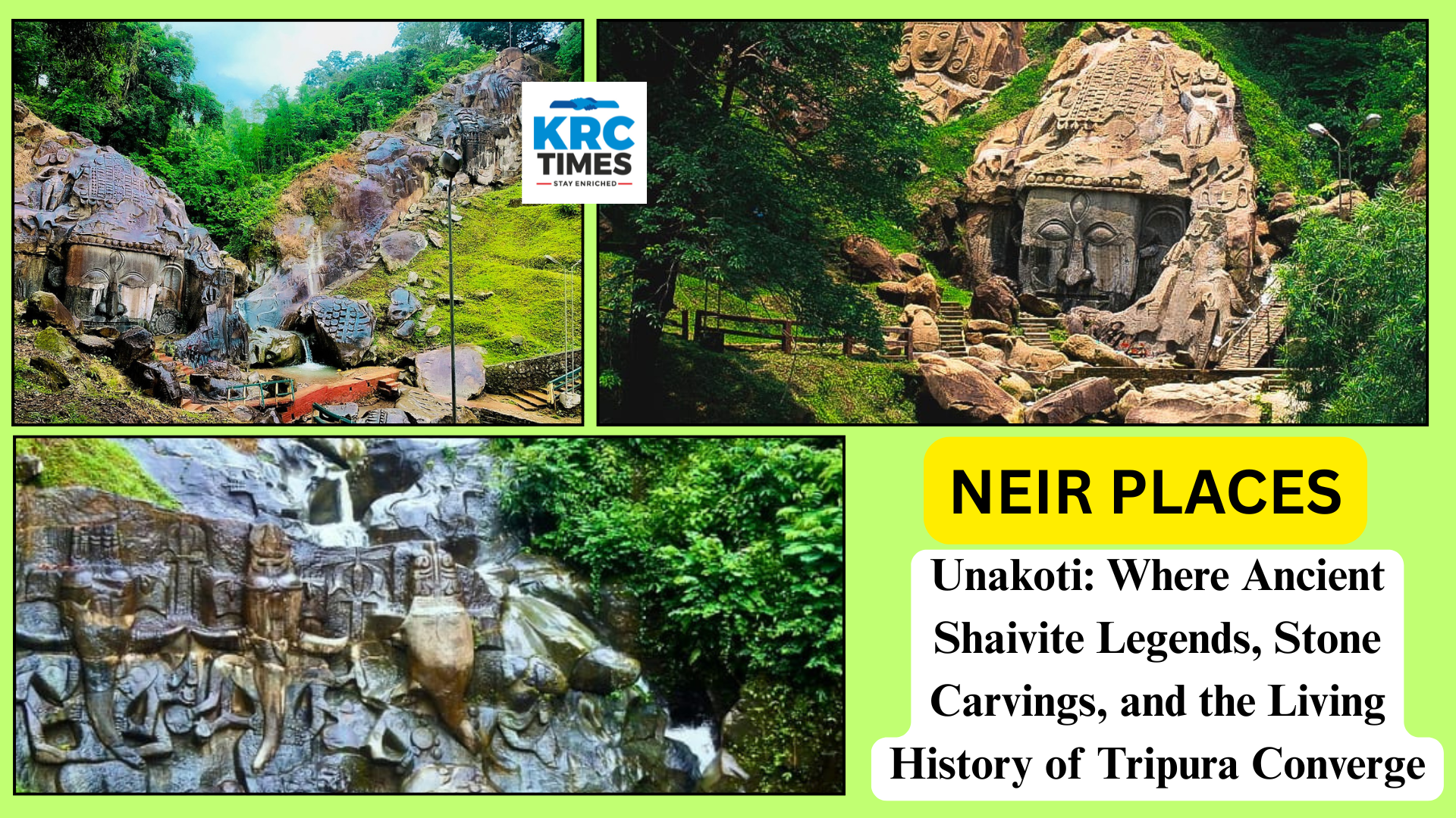
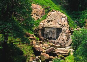
At its heart is the Unakoti hill, a site that has made Tripura visible on the spiritual map of India. The name itself tells a story. Unakoti literally means one less than a crore. Local legend says a crore of gods and goddesses once passed through this region on their way to Kashi under the leadership of Lord Shiva. When dawn broke, Shiva found that all but one had failed to wake up in time. Enraged, he turned them to stone. What remains are colossal rock-cut faces and reliefs, frozen in time, watching over the forested slopes.
The visual impact is immediate and overwhelming. Massive stone carvings of Lord Shiva dominate the landscape, especially the iconic Unakotiswara Kal Bhairava, whose towering face emerges directly from the rock. Around it are reliefs of Ganesha, Durga, Parvati, and other deities, carved with a mix of classical Hindu iconography and local tribal artistic sensibility.
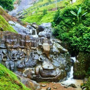
There is no neat symmetry here, no temple walls to frame the divine. The sculptures are part of the hill itself, shaped by human hands but inseparable from nature.
Waterfalls cascade nearby, particularly during the monsoon months, adding movement and sound to an otherwise still and solemn space. The setting feels deliberately untouched. Dense greenery, uneven paths, moss-covered stones, and the constant presence of water give Unakoti a meditative quality that goes beyond ritual. Pilgrims come to worship, tourists come to marvel, and both leave with the sense that this is not a site meant to be rushed.
Every year, Unakoti comes alive during the Ashokastami Mela, held in April. Thousands of devotees gather to take ritual baths in the nearby streams and offer prayers to Lord Shiva. For a few days, the quiet hills turn into a vibrant meeting point of faith, culture, and community. Temporary stalls, chants, and the hum of conversation fill the air, yet the ancient rock faces remain unchanged, observing another chapter of human activity unfold before them.
Beyond the pilgrimage site, Unakoti is also a district with a relatively young administrative history. It was carved out of North Tripura district in January 2012, with Kailashahar as its headquarters. Despite being the least populated district in the state, it stands out for its strong literacy rate, ranking fourth highest in Tripura. According to the 2011 Census, the district has a population of 2,76,506, with a near-balanced gender ratio and an overall literacy rate of 86.91 percent.
Administratively, Unakoti district is divided into two subdivisions, Kailashahar and Kumarghat, and four development blocks: Kumarghat, Pecharthal, Chandipur, and Gournagar. These divisions reflect an effort to manage development across both plains and hilly terrain, each with its own challenges and needs.
To understand Unakoti fully, it helps to place it within the larger historical arc of Tripura. The region was once part of the princely state ruled by the Manikya dynasty, a lineage that governed Tripura for centuries. Even during British rule, Tripura retained a degree of administrative independence, though always under British recognition as the paramount power. As recorded in the Rajmala, the royal chronicle of Tripura, 184 kings ruled the state before it merged with the Indian Union on 15 October 1949.
Post-independence, Tripura went through several administrative transitions. It became a C category state in 1950, a Union Territory in 1956, and finally attained full statehood in January 1972 under the North-East Reorganisation Act. District boundaries were redrawn multiple times to accommodate governance and development. North Tripura itself was formed in 1970, later giving rise to Dhalai district in 1995, and eventually Unakoti district in 2012.
Geographically, Unakoti district occupies a strategically sensitive and diverse space. It shares borders with several subdivisions of North Tripura on the northeast, east, and southeast, and with Dhalai district to the south. To the north, it touches the international border with Bangladesh, adding an element of geopolitical significance to its otherwise quiet profile.
The district’s climate follows a monsoon pattern, shaped heavily by its topography. Plains and hills experience noticeably different conditions. The plains tend to be hotter and more humid, while the hills enjoy a milder, more temperate climate. Four distinct seasons define the year: winter from December to February, pre-monsoon from March to May, monsoon from June to September, and post-monsoon from October to November. Temperatures generally range between 10 degrees Celsius in winter and 35 degrees Celsius at peak summer.
Rain plays a central role in shaping life here. Thunderstorms often begin as early as April, preceding the southwest monsoon, which arrives by June and continues through September. The heaviest rainfall is typically recorded in June and July, transforming the landscape into a lush green expanse and feeding the streams and waterfalls around Unakoti hill.

Connectivity has improved steadily over the years. National Highway 8 runs through the district, linking it to Assam and the southern parts of Tripura. Rail connectivity comes via the Lumding–Sabroom line of the Northeast Frontier Railway, with Kumarghat railway station serving as the main railhead in the district.
From here, passengers can travel to Agartala and other major towns like Dharmanagar, Udaipur, and Belonia, connecting Unakoti to the broader regional network.
Yet, despite better roads and railways, Unakoti retains a sense of distance from the hurried rhythms of urban India. Life here moves at a different pace, shaped by agriculture, local markets, festivals, and the changing seasons. The presence of the ancient Shaivite site is not just a tourist attraction but a living part of the district’s identity, influencing cultural practices and collective memory.
What makes Unakoti distinctive is this coexistence of the ancient and the administrative, the mythical and the measurable. On one hand, there are census figures, literacy rates, subdivisions, and blocks. On the other, there are legends carved into stone, worship rituals passed down generations, and a landscape that resists over-structuring.
Unakoti does not announce itself loudly. It does not rely on grand infrastructure or aggressive promotion. Its strength lies in quiet continuity. The rock faces remain, the hills stand firm, the waterfalls return every monsoon, and people continue to arrive, some with folded hands, others with curious eyes.
What this really means is that Unakoti is not just a destination. It is a reminder that history in the Northeast often survives not in textbooks or monuments behind fences, but in living landscapes where belief, art, and nature intersect. And in that intersection, Unakoti holds its place, one less than a crore, yet complete in its own way.
Promotional | North East Integration Rally