This collaborative training initiative represents a significant step forward in building and enhancing geospatial capacity within Manipur and the region
 Biswadeep Gupta

Manipur Remote Sensing Applications Centre (MARSAC) and CubeTen Technologies Pvt. Ltd. launched a 45-day intensive training program on Remote Sensing and Geographic Information Systems (GIS), here in Imphal.
The inaugural ceremony was held at CubeTen’s training facility at Mantripukhri and was jointly presided over by O. Nodiachand Singh, Director of MARSAC, and Haobam Joyremba, Managing Director of CubeTen Technologies Pvt. Ltd. Leishangthem Surjit spoke about the resource persons and trainer discussing their experiences and the projects that they have taken up along with their expertise.
This collaborative training initiative represents a significant step forward in building and enhancing geospatial capacity within Manipur and the region. In a rapidly digitizing world, the ability to harness spatial data through Remote Sensing and GIS technologies is vital for effective planning, environmental management, infrastructure development, agriculture, disaster preparedness, and many other sectors. With its increasing relevance in both government and industry, this training is designed to equip participants with critical knowledge and practical experience in the use of geospatial tools and platforms.
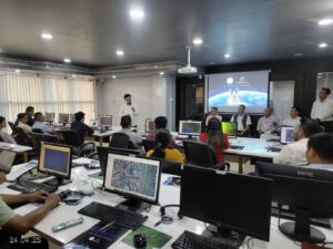
The training will be conducted by highly experienced scientists and domain experts from premier institutions such as MARSAC, North Eastern Space Applications Centre (NESAC), Indian Space Research Organisation (ISRO), Defence Research and Development Organisation (DRDO), and other reputed organizations.
The participants include government officials, university students, academic researchers, private sector professionals, and faculty members from various institutions. This diversity reflects the growing demand for geospatial literacy across disciplines and sectors.
In his inaugural address, Nodiachand, Director of MARSAC, emphasized the crucial role of Remote Sensing and GIS technologies in enhancing evidence-based decision-making and governance. He noted that “In Manipur’s context, where terrain, resource distribution, and disaster vulnerability are unique and complex, these technologies can offer robust solutions. From agricultural planning and water resource management to urban development and disaster response, Remote Sensing and GIS provide a modern toolkit for strategic action.”
Haobam Joyremba highlighted the importance of bridging the gap between academic learning and real-world applications. He stated, “This program is a testament to the growing synergy between public institutions and private enterprises. We at CubeTen believe that technology can be a great equalizer, and with the right training, our local talent can not only keep pace with but also contribute to global advancements in geospatial intelligence.”
This 45-day program comprises both theoretical modules and extensive hands-on training, including field data collection, satellite image interpretation, spatial data analysis, and GIS project development. The practical orientation of the course is intended to ensure that participants are not only familiar with the technology but are also capable of applying it to real-world problems in their respective domains.